Thursday, September 15, 2016

how the light . gets in


After my desert "adventure," it was unclear where I'd wander next. As most people I talked with were headed to Bryce Canyon and Zion, it seemed wise to go the other direction, which took me along the mostly two-lane stretch of asphalt considered the backbone of America. That's right, the famous Highway 50, dubbed in 1986 by Life Magazine as "The Loneliest Road in America."

Better men and women than I had braved this trail across Nevada and lived to tell the tale. Jack Kerouac wrote about it in the beat-era epic On the Road. William Least-Heat Moon waxed most eloquently about his classic, Blue Highways. If these dudes could do it, and survive, I surmised, I damn well could too.
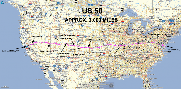
Following the trail of the Pony Express beginning in 1860 and the Lincoln Highway dating to 1913, the 3,007-mile Highway 50 winds its way from Ocean City, Maryland to Sacramento, California through alpine forests and desert valleys, passing ghost towns, dinosaur remains and national parks and through numerous small towns that are barely blips on the map.


My entrance onto 50 was to begin from Highway 21, which proved to be the most desolate part of the journey. It was bleak and absolutely carless except for the Zen Gypsy Van. Steep grades and hairpin turns through five mountain passes were to await me as I traveled from Ely to Austin, with long stretches of open landscape laced with gold grasses and wildflowers sandwiched between. The greatest danger proved to be deer. I kept a vigilant watch and had to slow for several herds along the way.

It was indeed a strange experience to see only a few cars along a 400-mile stretch. But it never felt lonely. It was more like a long, very peaceful, very rhythmic and convoluted conversation with your inner self. As Alexander Nazaryan noted in his Newsweek article, Route 50: Driving America's 'Loneliest Road,' " I suppose, then, that Route 50 can be considered a meditation retreat with a speed limit—mindfulness at 100 miles an hour." True. You became transfixed by the sound of your tires, mesmerized by the gold-grey clouds overhead, the seeming endlessness of the desert, and then yet another mystical mountain appearing like some kind of satori ahead. As Nazaryan also comments: "Whatever way the compass points, the true direction of the journey is always inward, ever deeper into the infinite soul of the land." Yes, indeed. Yes.

It was a soul road, for sure.


After 7 hours when my eyes began to blur, around Austin, I pulled over at The Cozy Mountain Inn, which proved to be just that . . . a simple, comfortable and heavenly respite for a weary traveler.  The owner, Cindy Walsh, was as welcoming as could be and we had fun talking about solo camping. She had just purchased a vintage teardrop camper and was getting ready to restore it and think about getting on the road herself.

I gassed up, and another 7 and a half hour drive through the rest of Nevada was alternately shockingly beautiful and bland. As the miles flew by, again through mountain ranges and valleys, I knew I was truly in the West, as now in addition to signs for deer and cow crossings, there were horse warnings (with flashing signs, no less!), though I never encountered a mustang. The small towns in between were forgettable strips of casinos, pawn shops, whore houses and beer joints. Now, I've been in my share of beer joints in my life, some of which are pretty fascinating crucibles for a writer, but none of the above were seductive enough to lure me in, even out of curiosity.


I sped past the salt flats, like a grey ocean stretching to the horizon on either side of the highway, where I could see the indentations of tire tracks of those who sought to test out speeds of up to 120 mph, and then into was on to the last stretch of Nevada and into well-populated Carson City. From there it was back up into the mountains where now very tall pine trees made my eyes water. Just to see this expanse of green again and to know I would soon be in California was like a balm for my tired eyes.

Coming into Tahoe City, however, after two days of almost total silence, was a shock. It was Labor Day Weekend and there were literally thousands of tourists milling about the cafes, bars, boutiques and the high-end casinos as well as throngs returning from 'Burning Man.' As I peered down this section of Highway 50, I saw an endless stream of cars, bumper-to-bumper, making a beeline into Lake Tahoe from Sacramento and San Francisco.

Far from the loneliest road now! I turned down Route 89 and headed through what looked like national forest. Ahhh. Quieter and quieter—until I came to a line of cars backed up for several miles. Uh oh. They were all turning into the destination dialed into my GPS, Camp Richardson, where I'd heard there were over 220 campsites. I entered the hotel there and inquired at the desk. Every single campsite and cottage was taken. Wow. Now what?

As I stood there, the clerk fielded a phone call. "There's no campsites," he said. "But we now have one room here at the hotel." I handed him my credit card. "You're one lucky duck," he told me. "Everything in town is booked."

I felt like flapping my wings and quacking. "Believe you me, mister, that's a proven fact!" I said. I tossed my pack in my room and made the 5-minute walk down to the beach restaurant to see if I could find myself a much-needed glass of wine. This turned out to be like divining for water in the backside of the Utah desert. The bar was packed ten-deep with drunken twenty-somethings and the roar of these crazed, half-naked revelers (well, there was an upside) was just too much for me to bear.

There was a funny moment when two guys carrying Piña Coladas walked out onto the deck. "Where'dj they go?" one muttered in slurred surprise, apparently referring to the girls they'd bought the drinks for, now long gone. "Bloody Bitches!" the other shouted, downing his Piña Colada in one swallow, and tossing the plastic cup in the trash. His friend shrugged, followed suit, then they turned, like twin inebriated ships, back towards the bar.

Welcome to what my daughter used to call, "sizzle-ization."

I skirted the bar buzz and strolled down the pier to the end where a "Rum Runner" cruise was about to depart. I talked to the owners for a bit then headed back to my sweet and simple room. There was no tv, just basically a bed and a bathroom. Still thirsty, I improvised and made a cocktail from some crushed ice, the final drop of vodka in my cooler and the last already somewhat mashed-up Palisade peach. It was pretty darn good if I do say so myself! I made a supper of some good goat cheese, crackers and salami and sank into a well-deserved slumber.


I was now in striking distance of home, but I had one more important item on my Zen Gypsy list—to see my good friends Susanna and Jimmy Cubbage, who now lived in Tahoe. That morning I toured the lake itself on the way to their place in Incline Village, which gave me new insight into how absolutely stunning this area is. Along the way I stopped at Rosie's Diner for some good coffee and a bit of breakfast. The place was packed, but I managed to squeeze in at the bar and had a nice time chatting with the bartender, who at one point, downed a shot of Jack Daniels. "Breakfast," he said, smiling and wiping his moustache. I toasted him with my coffee. I believe I was the only one in the place who wasn't drinking a Mimosa or a Bloody Mary or some other brunch concoction. Tempting, but I still had some mountain driving to do.

My time with my dear friends and their dog, Zoey, was like gold. They took me on a lovely hike through one of the most beautiful meadows I've ever seen and served me a fabulous dinner of roasted salmon, good hearty salad and my friend Susanna's famous homemade rye bread. Having a home-cooked meal with people you love was one of the best things that happened to me along the way. It was a tearful farewell (never goodbye!) the next morning, but I felt so blessed to have gotten to spend some quality time with them.


And, this golden glow followed me all the way to San Francisco. My travels were almost over, but the memories made on those 3,500 miles kept floating back to me—the friendly faces, the fantastical sights and scenery, both the scary and serene moments, all blended into a blissful, surreal blend of what to me was truly magic.

I'd danced before life and death, come face-to-face with angels in the desert, come through the fire and been made more whole because of it.

Somehow, I had made it all the way from east to west, from there to here, from where to wherever. I'd been transformed both within and without, my hair bleached to sand, my skin burned to the color of the desert stones, my mind cleansed of any preconceptions of what this next chapter of my life would be.

But I knew I still had a lot of inner traveling and unraveling ahead . . . 


Saturday, September 10, 2016

the meander . the mistake . the miracle


Chimney Rock
Capitol Reef National Park

Capitol Reef National Park.

I was born a child of woods and water and northern stars, well familiar with navigating rivers and lakes. Now, I had come to embrace, even to love, the austerity, the simplicity of the desert. I had moved past my fear of this strange and alien landscape to settle into a place of calm acceptance and peace, as well as a potentially deadly confidence (whetted by my uneventful hikes at The Arches and Dead Horse Point).

As the clouds formed and flowed over the mountains, the sun rose and set in Technicolor rivers as striated as the illumined canyons. The Waterpocket Fold cliffs, created over 280 million years and composed of 10,000 sedimentary feet of limestone, sandstone and shale, were dramatic and unworldly.

According to the park literature:

Capitol Reef's defining geologic feature is a wrinkle in the Earth's crust, extending nearly 100 miles, from Thousand Lake Mountain to Lake Powell. It was created over time by three gradual, yet powerful processes—deposition, uplift, and erosion. They are defined as a classic example of a monocline or one-sided fold in the otherwise horizontal rock layers.

Slowly, unexpectedly, I found myself becoming one with the heartbeat of this ancient place.

Nestled along the Fremont River, The Fruita Historic District, where I was camping, was a unique oasis in the midst of Capitol Reef National Park, with orchards of apples, pears and peaches blanketing the valley. You were (unofficially) encouraged to step outside of your campsite, walk a few yards, and pluck an apple from a tree anytime you wished. It truly like was a Garden of Eden. Even the mule deer found it so. They wandered freely and unafraid through the campground, eating apples from the ground and sleeping just steps away from our tents.


This peaceful reprieve from the many dusty miles I'd traveled seemed like a gift from heaven. After a day, I felt refreshed and recharged. I had consciously tried to take every opportunity to swim and hike, to counteract the effects of sitting for long periods in the car. Now I was ready to challenge myself again physically.

The Fremont River

I chose as my first hike, the moderate Fremont River Trail which began at my campsite and took me along a cool path parallel to river, then straight up the mountain on a fairly demanding 1,000-foot change in elevation (from roughly 5,100 to 6,400 feet). The trail consisted of a rocky and shale-strewn foot-wide path (sometimes less) along drop-offs that any error in footing would surely result in plunging one onto the rocks below. I walked carefully and with great attention, grateful to have a good pair of boots, and although the altitude forced me to stop and rest, both on the way up and on the way back, it felt very good and healthy to be once again exploring and out in the fresh, sage-scented air. The vista at the top was certainly worth the effort. Ahhh . . .

View from My Tent

Back at the campground, I met a handsome couple, Rhonda and John McNally, who showed me their Sylvan Sport Geo setup and gave me insight into the Zion area. Had I known such a thing existed, I might have rethought my Zen Gypsy Van, but I made a mental note for future travels.

Rhonda and John McNally
and their cool Sylvan Sport Geo
I also chatted with a couple from Pennsylvania, who stopped with me to marvel at the beauty of the red-running river and the cottonwood trees.

And, also along the river, I met a kindred spirit, a musician and healer named Judy Piazza, and had a delightful conversation with her that felt like a tonic.

Judy Piazza
(Isn't she adorable?)


the meander.

The next morning, for some ironic reason my first waking thought was, "Today is Challenge Day." I was anxious to push myself a bit physically, to continue to hone my muscles and lungs, to adapt to the elevation and the environment. I'd been told about Chimney Rock by a young photographer I'd met who was on a trek cross country on assignment. He shared lots of useful information about his own travels and I much admired his spunk and creative spirit.

After the Fremont River Trail, Chimney Rock, a 90-minute, 3.6-mile roundtrip hike, with a 590-foot change in elevation, seemed very do-able by myself (Mistake #1, hiking alone in unfamiliar territory) and I set out about 9 am to begin my ascent. Chimney Rock was characterized by the park as "strenuous" and as I had carried way too much gear on my Fremont River climb I made the decision to lighten up and began jettisoning stuff from my pack. This included an extra-large water bottle, which had proved heavy and a bit unstable in my pack the day before. (Mistake #2, not bringing adequate water).


At the trailhead I met a couple who encouraged me to do the hard hiking first, to go straight up and then to take the loop through the Spring Canyon on the way down. "Spectacular!" they said, their faces flushed with excitement. Their enthusiasm was a bit of serendipity that was to have serious consequences for me later on.

I started up. There were 5-6 cars and a kiosk at the trailhead, but no sign-in sheet. I was anxious to get going before the day began to heat up. I knew there were people up there on the mountain and believed that it would be an easy up and easy down, according to the couple I'd met, so (Mistake #3, depending on second-hand information) I plunged ahead.


The climb up was a lot rougher than I anticipated. By the time I reached "the money shot" from Panoramic Point and the view of Chimney Rock, I was winded and since there was still a bit of ascent left, forgot to even take a photo of the truly magnificent view. The way down was easier, but somewhat more treacherous. Loose shale, the thin trail and drop-offs on the edge of Whiskey Flat made me lose my breath and literally hug the side of the mountain, and contributed to a somewhat stressful descent.

I reached the sign that indicated the side loop to Spring Canyon indicating that it was another two miles, roundtrip. I checked in with myself. I was a little tired, probably more stressed that I admitted, but I felt okay. I still had almost 3/4 of a bottle of my 16-oz bottle of water and though probably up in the 90s, the heat was bearable. I turned and took the side trail. (Mistake #4, pushing myself past my endurance).

* * *

the mistake.

As I hiked the what I thought was Spring Canyon, I found myself at numerous splits in the trail that went three different different directions. I followed the human tracks. What I did not realize had I looked at the map (Mistake #5, not understanding the topography) was that there was a longer, 11-mile trail that led back to another point on the highway.


Somewhere along the way, I must have turned onto that trail. I kept walking, enthralled by the straight-up canyon walls, the amazing vistas of sky and stone. After another hour of hiking, I became puzzled. Surely I should be back at the trailhead by now!

The trail was following a gulley through the canyon, with sand that had become moist, moist enough to show that there were now no human tracks, only those of bighorn sheep, coyote and . . . cougar. I began to panic a bit. There were dark clouds forming to the west and clearly I was in an area that had seen a recent flash flood. My eyes scrutinized the banks for places to climb up should that occur, but for the most part the walls were straight up. And, worse, I was running out of water.

Like death? Perhaps. And perhaps that is why life nowhere appears
so brave, so bright, so full,
so full of oracle and miracle
as in the desert.

- Edward Abbey

I began to panic, I decided to follow my tracks back, but got turned around probably two or three times. I somehow reached another sign. It said, "6.5 miles to Highway 24" and pointing back the way I'd just come,"3 miles to Chimney Rock trailhead." By this time, I was trying to conserve my water, but was clearly becoming dehydrated, suffering intermittent bouts of heat stroke and highly stressed emotionally. I couldn't think straight, but I knew I was in big trouble.


I couldn't bear the thought of almost another 7 miles, in fact, I was so disheartened by this, that I began to cry. I could see how people got to a place of despair and fear so great that they would give up and surrender to the elements. I was now prey and the wilderness was about to eat me alive. Even so, there was a kind of strange peace in that. If indeed it was my time to go, at least, I hoped, it would be fairly quick.

My face was burning. My ears were pounding. The water was gone. No one knew I was here. Even if I could find the trail, I knew I might not make it, as I probably had already been walking 10-15 miles in addition to the original climb up and back from Chimney Rock. I felt so ridiculous, but I didn't even have the energy to beat myself up about all the mistakes I'd made. Instead, I lay down for awhile in the shade of a rock, just trying to breathe to keep myself calm. I felt I could just melt into the ground, to become one with the sandstone, the blood-red cliffs, the blazing sun overhead.


It was then that I heard it. The voice. I knew instantly who it was. My childhood friend Linda Clayton Faubel had worked and saved her entire life with the intent to travel the world. A week before she was ready to retire, she suffered a heart attack and died, never to realize her life dream. This had constantly been on my mind throughout my travels, in fact, it may have been one of the keys to my sense of urgency in manifesting the Zen Gypsy Van.

Linda, dear Sweet Angel Linda. Her voice was calm, clear, and very loving. I could feel her presence so strongly, like a warm, energizing hug. "Get up," she insisted. "Get up and don't lose hope. Get up and keep walking. You can do this." Behind her, I could feel the presence of other beings, including another childhood friend, Tacy Claphanson, who had also died not long ago, and that of my adopted grandparents Alma and George Johnson; my second mother, Annemarie Roeper; my maternal and paternal grandmothers; and that of my father, who was silent and seemed very worried. I tried not to focus on his concern.

So I turned back. I forced myself to walk. Walk, walk, walk, I told myself. Don't lose hope, hope, hope. A friend of mine from Berkeley, musician and producer Dave Delavega, once showed me how to meditate while walking. "Match your breath to your step," he'd instructed. I thought about this and took his advice and it seemed to help to propel me along. I had a whistle with me and I began to blow it each time I came to a turn, or a split in the trail, but the only sound was that of my own labored breath, and the eerie echoes bouncing off the canyon walls.

It began to rain. Now I was petrified that I'd be washed away in a flood. The rain cooled me some and I tried to gather as much moisture as I could in my water bottle and my hat. The shower was brief, but enough to blur my own tracks in the sand. At least at this point I could see places that I could climb up if necessary. I decided to focus on that. (Mistake #6, going off trail again and again). This brought me up above the flood line, but into an area where I had no bearings whatsoever.

At this point, the wind began to gust somewhat fiercely, accompanied by spatters of rain. I made my way through boulders and briars to the ridge, but once there, had to crawl along the thin rise, afraid that the wind would blow me off the mountain. The storm worsened, so I climbed down among some rocks and a pinyon tree (dear pinyon tree!) out of the wind. I realized that I might have to spend the night on the mountain, which in some ways was even scarier, as I knew hypothermia would definitely be an issue.

I gathered some twigs and brush in the hope of being able to make a fire. Now remember, I was no Girl Scout. (In fact, I'd been kicked out of the Brownies for refusing to make potholders.) I had never been camping before by myself. I knew how to build a decent fire, because I had heated my farmhouses with wood, but always with a lighter, or at least matches at the ready. Matches! The whistle I carried had a little compartment. I twisted it open and, yes!, there were a few matches tucked inside. I tried to get a flame going, but the wind was too intermittent and harsh. Aghhh!

I was actually getting chilled now. I knew I had a sweater in my pack, and while searching for it, discovered that I had my phone. I was so disoriented that I'd forgotten it was in my pack. I assumed it was dead, as there was no electric or WiFi at the campground and I hadn't had an opportunity to charge it. (Mistake #7, not having a fully-charged phone or GPS). In the labyrinth of the canyons there would have been no reception anyway.

the miracle.

There was 2% left on the battery. The wind abated for a moment and I climbed back on the ridge. I dialed 911. And, lo and behold, miracle upon miracles, someone answered.

The operator listened to me frantically explain where I was and that I had little juice left on my phone. She calmed me down and assured me that they would try to get a fix on me and we hung up. A few seconds later, a park ranger called. "We are going to go to the trailhead and sound our sirens," he told me. "Listen for the sirens and then walk in that direction. In the meantime, we will send someone to find you, but it might take a few hours."

Then, my phone went dead.

Sure enough, about five minutes later, I heard their sirens. I began to walk in that direction and in a few miles saw the trail kiosk far below. When I neared the last part of the trail, Ranger Rick, an off-duty park ranger, was coming up. When I saw him, I was so relieved to see another human being, that I'm embarrassed to say I fell to my knees and began sobbing, somewhat hysterically. He gave me some water and helped me up and pointed me gently down the trail. "Keep going," he assured me. "You're almost there."

My Heroes!

At the bottom, standing near their cars, were the three men who orchestrated my rescue: Micah Gulley of the Wayne County Sheriff's office (who talked with me on the phone), Kurt Taylor (Sheriff of Wayne County), and Mike Zirwas, of the National Park Service, Department of the Interior. Together, they were responsible for policing 2,466 square miles of Utah desert. They chastised me (rightfully so) for hiking alone, and I promised them that I had learned my lesson.

"You are one lucky, lucky girl," they all agreed.

"Thank you! Thank you! Thank you!" I repeated over and over. I couldn't help but give each of them a great big hug. Another hiker whom I met on the last twist of the trail wandered down off the mountain because of the high wind and he kindly offered to take a photo of all us. I never did get his name, but I thank him and his consideration.

Last, but not least, my great respect and undying gratitude go to the operator who answered my call, and was instrumental in my rescue. To her, and to Micah, Kurt and Mike, I owe my very life.


* * *

At this point you are probably thinking that I was either half-crazy or just plain dumb to embark alone on such a perilous trek, and you'd be absolutely right on both counts. I attribute (a.) my over-confidence in my own abilities, (b.) my desire to challenge myself and (c.) my lack of experience as the chief factors that overrode any good common sense. None of them are an excuse.

Lesson (or lessons) Learned. My gratitude for my survival and to those who saved me is a daily, impassioned prayer . . . It would be impossible at this point to describe here how profoundly this experience has changed me.  

Note: It has taken me until now to fully realize the extreme folly of my actions that day, and to process through the very real potential that without divine intervention, I most likely would have died out there in the desert that day.

In retrospect, my biggest downfalls (after hiking alone) were not bringing enough water and not researching the terrain.

For future trekkers, here again are the classic errors I made, in the hope that you will take them to heart anytime you go into the wild, or any trail for that matter. Please add to them your own observations and wisdom. Above all, listen to those who have experienced the terrain and always, always, bring enough water!

Mistake #1, hiking alone in unfamiliar territory. Always, always let someone know when you are on the trail alone!

Mistake #2, not bringing adequate water. Bring twice what you think you might need on the trail. In the desert, that can equal a 1/2 gallon per 4-hour period. (I had 16 ounces with me and I was lost for six hours.)

Mistake #3, not studying a map and depending on second-hand information.

Mistake #4, pushing myself past my true endurance. Recognize when you are tired or unprepared for the elevation of territory ahead.

Mistake #5, not knowing the topography. Although I had a compass, I did not adequately understand where I was. I assumed, wrongly, and almost fatally, that the trail would be well marked.

Mistake #6, going off trail again and again. I backtracked myself several times over while I was dehydrated, losing precious energy, and getting more and more panicked and turned around.

Mistake #7, not having a fully-charged phone or GPS device with me.

The Welcome Signs of Civilization